As a society, we use land in many different ways. The way …
As a society, we use land in many different ways. The way we use land has a tremendous impact on how water flows over and through land as it makes it way to streams, rivers, and the Great Lakes. When rainwater falls on land, it gradually makes its way downhill. In developed areas, including both farms and urban areas, there is much less vegetation to slow the water down. As a result, the water moves quickly over the surface of the ground, picking up dirt and other materials and carrying it along with the flow of water. This process is known as "erosion." The suspended material, called "sediment," is carried through the watershed to the streams, rivers, and lakes. Success with this lesson will happen when students are able to explore the land use around sample Michigan sites, and use that information to analyze which sites have the highest average sediment levels and which have the lowest.
Rivers are incredibly important to our society and our environment, but we …
Rivers are incredibly important to our society and our environment, but we haven't always treated our rivers as well as we should. By using pictures taken from satellites orbiting the earth, we can examine rivers all over Michigan and try to identify those rivers that appear to have higher water quality and those that appear to have lower quality. Based on the illustrations provided, students will be able to make a number of observations about the quality of Michigan's rivers. Two specific rivers, the Rouge River and Escanaba River, will be observed and conclusions made about water quality and types of land use surrounding it. Lesson success will include having students log into ArcGIS Online to explore the river nearest their home so they can produce a table of observations and a 3-5 sentence paragraph to summarize their findings.
There are many different ways to precisely measure the quality of water …
There are many different ways to precisely measure the quality of water in a river. Environmental scientists and volunteers all over the state of Michigan are continuously collecting measurements of the quality of water in rivers, streams, and lakes. Students will look at two of these measures to see how they change with location around the state and along a river. The first measure of water quality is called "water conductance" - that is, how well a water sample can conduct electricity. A higher water conductance generally means lower water quality. The second measure of water quality is "pH." pH is a measure of how acidic or basic water is. Successful students will be able to interpret and analyze data using these two measures to better understand Michigan water quality.
As rain falls all over Michigan, the water gathers in small local …
As rain falls all over Michigan, the water gathers in small local watersheds, which feed into larger regional watersheds, which ultimately feed into the Great Lakes. Water that falls on the land in Michigan eventually flows into one of the Great Lakes because the elevation of the Great Lakes is generally lower than the elevation of the land in Michigan. Students will be able to use elevation maps to study water flow from watersheds emptying into the Great Lakes. Success with this lesson will happen when students can investigate the Great Lakes water flow and produce a simple diagram that illustrates this flow pattern.
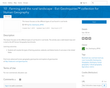
This activity focuses on the different types of land use found in …
This activity focuses on the different types of land use found in rural landscapes.
GeoInquiries are designed to be fast and easy-to-use instructional resources that incorporate advanced web mapping technology. Each 15-minute activity in a collection is intended to be presented by the instructor from a single computer/projector classroom arrangement. No installation, fees, or logins are necessary to use these materials and software.
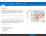
Student's objective in this project is to ensure the programs are offered …
Student's objective in this project is to ensure the programs are offered where they're most needed. To do so, students create a map by adding and enriching a layer of ZIP Codes with demographic data from ArcGIS Online. They also apply smart mapping and style the layer to show median household income by ZIP Code area. Then, they change the layer style to show median household income and child population, to identify which areas have the most children living in poverty. Students also configure the pop-ups to make the demographic information easier to read. Lastly, they report their findings to top donors and partner organizations by configuring a web app that tells a clear story based on their data.
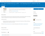
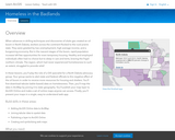
As the United States acquired land and new states formed, the balance …
As the United States acquired land and new states formed, the balance of power between the free and slave states needed to be addressed.
GeoInquiries are designed to be fast and easy-to-use instructional resources that incorporate advanced web mapping technology. Each 15-minute activity in a collection is intended to be presented by the instructor from a single computer/projector classroom arrangement. No installation, fees, or logins are necessary to use these materials and software.
In this project, students take a tour of the Urban Observatory. They …
In this project, students take a tour of the Urban Observatory. They navigate and compare thematic maps to investigate the spatial trends affecting the landscapes of the world's largest cities. Ultimately, students use the Urban Observatory to ask their own question about space and place, learning about our world in the process.
Explore the movement and exchange of plants, animals, and diseases from the …
Explore the movement and exchange of plants, animals, and diseases from the Old World to the New World and the New World to the Old World.
GeoInquiries are designed to be fast and easy-to-use instructional resources that incorporate advanced web mapping technology. Each 15-minute activity in a collection is intended to be presented by the instructor from a single computer/projector classroom arrangement. No installation, fees, or logins are necessary to use these materials and software.
In these lessons, students play the role of a GIS specialist for …
In these lessons, students play the role of a GIS specialist for a North Dakota advocacy group. The group wants to alert state and federal officials to this negative effect of the oil boom in order to receive more resources for housing and shelters. Students first download tabular (table-based) data on homelessness. Then, they map the data in ArcMap by joining it to state geography. They publish their map layer to ArcGIS Online and make a set of online maps anyone can access. Finally, students present their maps in a single, easy-to-understand web app.
Investigate the progression of communist expansion immediately following World War II. GeoInquiries …
Investigate the progression of communist expansion immediately following World War II.
GeoInquiries are designed to be fast and easy-to-use instructional resources that incorporate advanced web mapping technology. Each 15-minute activity in a collection is intended to be presented by the instructor from a single computer/projector classroom arrangement. No installation, fees, or logins are necessary to use these materials and software.
Explore relationships between temperature, pressure, and humidity with daily weather forecasts. GeoInquiries …
Explore relationships between temperature, pressure, and humidity with daily weather forecasts.
GeoInquiries are designed to be fast and easy-to-use instructional resources that incorporate advanced web mapping technology. Each 15-minute activity in a collection is intended to be presented by the instructor from a single computer/projector classroom arrangement. No installation, fees, or logins are necessary to use these materials and software.
Students will explore the spatial patterns of the Human Development Index (HDI) …
Students will explore the spatial patterns of the Human Development Index (HDI) to identify regional patterns and causal factors in the data.
GeoInquiries are designed to be fast and easy-to-use instructional resources that incorporate advanced web mapping technology. Each 15-minute activity in a collection is intended to be presented by the instructor from a single computer/projector classroom arrangement. No installation, fees, or logins are necessary to use these materials and software.
This activity follows the path of human migration from Africa to the …
This activity follows the path of human migration from Africa to the far reaches of the globe.
GeoInquiries are designed to be fast and easy-to-use instructional resources that incorporate advanced web mapping technology. Each 15-minute activity in a collection is intended to be presented by the instructor from a single computer/projector classroom arrangement. No installation, fees, or logins are necessary to use these materials and software.
In this project, students perform a viewshed analysis to determine the visual …
In this project, students perform a viewshed analysis to determine the visual impact of a wind farm with four large turbines in a study area in England. A viewshed is the area visible from a specific vantage point. Viewshed analysis shows areas where observers can see an object or objects, or conversely, areas that can be seen from those objects. Although a complete wind farm analysis would examine other factors as well, these lessons focus on the visual impact assessment portion of the analysis. Students assess the visual impacts of building the wind farm by generating maps of zones of theoretical visibility under various assumptions.
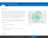
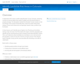
In this project, students identify areas at highest risk of flooding and …
In this project, students identify areas at highest risk of flooding and landslides during a major rain event. They first explore the region's dramatic geography and identify how the most flood-prone areas correspond with large population centers. Then, they determine where landslides are most likely to occur and summarize the population in these at-risk areas. Overall, students get a picture of the dangers faced in Boulder County and the costs associated with rebuilding in the wake of catastrophe.
This activity examines species richness to gain insight to evolutionary selection factors …
This activity examines species richness to gain insight to evolutionary selection factors that encourage greater diversity.
GeoInquiries are designed to be fast and easy-to-use instructional resources that incorporate advanced web mapping technology. Each 15-minute activity in a collection is intended to be presented by the instructor from a single computer/projector classroom arrangement. No installation, fees, or logins are necessary to use these materials and software.
Students will explore patterns of cultural diffusion through linguistic and religious data. …
Students will explore patterns of cultural diffusion through linguistic and religious data.
GeoInquiries are designed to be fast and easy-to-use instructional resources that incorporate advanced web mapping technology. Each 15-minute activity in a collection is intended to be presented by the instructor from a single computer/projector classroom arrangement. No installation, fees, or logins are necessary to use these materials and software.
Investigate marine debris, the role of ocean gyres, and how humans impact …
Investigate marine debris, the role of ocean gyres, and how humans impact trash accumulation.
GeoInquiries are designed to be fast and easy-to-use instructional resources that incorporate advanced web mapping technology. Each 15-minute activity in a collection is intended to be presented by the instructor from a single computer/projector classroom arrangement. No installation, fees, or logins are necessary to use these materials and software.
Explore urban sprawl, factors, and impacts. GeoInquiries are designed to be fast …
Explore urban sprawl, factors, and impacts.
GeoInquiries are designed to be fast and easy-to-use instructional resources that incorporate advanced web mapping technology. Each 15-minute activity in a collection is intended to be presented by the instructor from a single computer/projector classroom arrangement. No installation, fees, or logins are necessary to use these materials and software.
No restrictions on your remixing, redistributing, or making derivative works. Give credit to the author, as required.
Your remixing, redistributing, or making derivatives works comes with some restrictions, including how it is shared.
Your redistributing comes with some restrictions. Do not remix or make derivative works.
Most restrictive license type. Prohibits most uses, sharing, and any changes.
Copyrighted materials, available under Fair Use and the TEACH Act for US-based educators, or other custom arrangements. Go to the resource provider to see their individual restrictions.