Students will use ArcGIS Online to evaluate migration at the global, regional, …
Students will use ArcGIS Online to evaluate migration at the global, regional, and local scales.
GeoInquiries are designed to be fast and easy-to-use instructional resources that incorporate advanced web mapping technology. Each 15-minute activity in a collection is intended to be presented by the instructor from a single computer/projector classroom arrangement. No installation, fees, or logins are necessary to use these materials and software.
Analyze the quantities and origins of basic mineral resources. GeoInquiries are designed …
Analyze the quantities and origins of basic mineral resources.
GeoInquiries are designed to be fast and easy-to-use instructional resources that incorporate advanced web mapping technology. Each 15-minute activity in a collection is intended to be presented by the instructor from a single computer/projector classroom arrangement. No installation, fees, or logins are necessary to use these materials and software.
This activity illustrates how global mountain ranges are formed related to plate …
This activity illustrates how global mountain ranges are formed related to plate motions.
GeoInquiries are designed to be fast and easy-to-use instructional resources that incorporate advanced web mapping technology. Each 15-minute activity in a collection is intended to be presented by the instructor from a single computer/projector classroom arrangement. No installation, fees, or logins are necessary to use these materials and software.
This activity provides a geographic overview of the American Civil War. GeoInquiries …
This activity provides a geographic overview of the American Civil War.
GeoInquiries are designed to be fast and easy-to-use instructional resources that incorporate advanced web mapping technology. Each 15-minute activity in a collection is intended to be presented by the instructor from a single computer/projector classroom arrangement. No installation, fees, or logins are necessary to use these materials and software.
Explore the spatial patterns of Native American lands in 1819 and the …
Explore the spatial patterns of Native American lands in 1819 and the decrease in size of those lands through the current Native American reservations.
GeoInquiries are designed to be fast and easy-to-use instructional resources that incorporate advanced web mapping technology. Each 15-minute activity in a collection is intended to be presented by the instructor from a single computer/projector classroom arrangement. No installation, fees, or logins are necessary to use these materials and software.
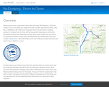
In this project, students will learn how to find the area that …
In this project, students will learn how to find the area that drains to a storm drain and the route that pollutants will take if they are dumped or washed into the drain. They will find the upstream drainage area, called a watershed, for a storm drain near Blackman Elementary School in Tennessee. Then they find the downstream flow path to where it empties into the Gulf of Mexico. Knowing how to find these, students can experiment to find the watersheds and flow paths from other storm drain locations.
Introduce and explore various types of landforms. GeoInquiries are designed to be …
Introduce and explore various types of landforms.
GeoInquiries are designed to be fast and easy-to-use instructional resources that incorporate advanced web mapping technology. Each 15-minute activity in a collection is intended to be presented by the instructor from a single computer/projector classroom arrangement. No installation, fees, or logins are necessary to use these materials and software.
Categorize sections of the oceans and understand their importance. GeoInquiries are designed …
Categorize sections of the oceans and understand their importance.
GeoInquiries are designed to be fast and easy-to-use instructional resources that incorporate advanced web mapping technology. Each 15-minute activity in a collection is intended to be presented by the instructor from a single computer/projector classroom arrangement. No installation, fees, or logins are necessary to use these materials and software.
Students learn about the geography and significance of the D-Day invasion. GeoInquiries …
Students learn about the geography and significance of the D-Day invasion.
GeoInquiries are designed to be fast and easy-to-use instructional resources that incorporate advanced web mapping technology. Each 15-minute activity in a collection is intended to be presented by the instructor from a single computer/projector classroom arrangement. No installation, fees, or logins are necessary to use these materials and software.
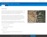
In this lesson, students take on the role of a county official …
In this lesson, students take on the role of a county official tasked with spreading awareness of the disaster. Using imagery of the affected area, they create a web mapping application that allows users to easily compare the area before and after the disaster. Users should also to be able to measure the extent of the impact. Lastly, the app should link to additional material about the landslide.
Investigate how properties of volcanoes are influenced by the crust and plate …
Investigate how properties of volcanoes are influenced by the crust and plate boundaries nearest them.
GeoInquiries are designed to be fast and easy-to-use instructional resources that incorporate advanced web mapping technology. Each 15-minute activity in a collection is intended to be presented by the instructor from a single computer/projector classroom arrangement. No installation, fees, or logins are necessary to use these materials and software.
Compare country-age structures to long-term population growth. GeoInquiries are designed to be …
Compare country-age structures to long-term population growth.
GeoInquiries are designed to be fast and easy-to-use instructional resources that incorporate advanced web mapping technology. Each 15-minute activity in a collection is intended to be presented by the instructor from a single computer/projector classroom arrangement. No installation, fees, or logins are necessary to use these materials and software.
This actity explores abiotic factors associated with primary productivity. GeoInquiries are designed …
This actity explores abiotic factors associated with primary productivity.
GeoInquiries are designed to be fast and easy-to-use instructional resources that incorporate advanced web mapping technology. Each 15-minute activity in a collection is intended to be presented by the instructor from a single computer/projector classroom arrangement. No installation, fees, or logins are necessary to use these materials and software.
Students consider place-based hazards using remote-sensed data. GeoInquiries are designed to be …
Students consider place-based hazards using remote-sensed data.
GeoInquiries are designed to be fast and easy-to-use instructional resources that incorporate advanced web mapping technology. Each 15-minute activity in a collection is intended to be presented by the instructor from a single computer/projector classroom arrangement. No installation, fees, or logins are necessary to use these materials and software.
This activity highlights patterns of poverty and wealth to address overconsumption and …
This activity highlights patterns of poverty and wealth to address overconsumption and resource extraction.
GeoInquiries are designed to be fast and easy-to-use instructional resources that incorporate advanced web mapping technology. Each 15-minute activity in a collection is intended to be presented by the instructor from a single computer/projector classroom arrangement. No installation, fees, or logins are necessary to use these materials and software.
Examine patterns of where rock types form and the relationship they have …
Examine patterns of where rock types form and the relationship they have toward each other
GeoInquiries are designed to be fast and easy-to-use instructional resources that incorporate advanced web mapping technology. Each 15-minute activity in a collection is intended to be presented by the instructor from a single computer/projector classroom arrangement. No installation, fees, or logins are necessary to use these materials and software.
Students will explore the location and distribution of religiously sacred sites around …
Students will explore the location and distribution of religiously sacred sites around the world.
GeoInquiries are designed to be fast and easy-to-use instructional resources that incorporate advanced web mapping technology. Each 15-minute activity in a collection is intended to be presented by the instructor from a single computer/projector classroom arrangement. No installation, fees, or logins are necessary to use these materials and software.
This activity investigates causes of disease and ways to control malaria. GeoInquiries …
This activity investigates causes of disease and ways to control malaria.
GeoInquiries are designed to be fast and easy-to-use instructional resources that incorporate advanced web mapping technology. Each 15-minute activity in a collection is intended to be presented by the instructor from a single computer/projector classroom arrangement. No installation, fees, or logins are necessary to use these materials and software.
This activity explores potential and developed wind capacity by state as well …
This activity explores potential and developed wind capacity by state as well as challenges that Texas has faced to develop wind power.
GeoInquiries are designed to be fast and easy-to-use instructional resources that incorporate advanced web mapping technology. Each 15-minute activity in a collection is intended to be presented by the instructor from a single computer/projector classroom arrangement. No installation, fees, or logins are necessary to use these materials and software.
Explore the growth of steel in the United States, using Pittsburgh as …
Explore the growth of steel in the United States, using Pittsburgh as a case study.
GeoInquiries are designed to be fast and easy-to-use instructional resources that incorporate advanced web mapping technology. Each 15-minute activity in a collection is intended to be presented by the instructor from a single computer/projector classroom arrangement. No installation, fees, or logins are necessary to use these materials and software.
No restrictions on your remixing, redistributing, or making derivative works. Give credit to the author, as required.
Your remixing, redistributing, or making derivatives works comes with some restrictions, including how it is shared.
Your redistributing comes with some restrictions. Do not remix or make derivative works.
Most restrictive license type. Prohibits most uses, sharing, and any changes.
Copyrighted materials, available under Fair Use and the TEACH Act for US-based educators, or other custom arrangements. Go to the resource provider to see their individual restrictions.